Cut Both Ways: USU Scholars Study Causeway Effects on Great Salt Lake
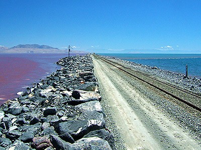
A causeway dividing Great Salt Lake creates the ultra-saline North Arm, left, and the less salty South Arm, right. USU researchers are seeking solutions that balance the lake's ecology and stakeholder interests. Photo by Wayne Wurtsbaugh, USU.
Viewed from above, Utah’s Great Salt Lake reveals a distinctive divide. To the south, the waters appear an unsurprising bluish-green. To the north, the waves display an unusual rosy hue. The divergent colors stem from a nearly 20-mile-long causeway, constructed by Union Pacific Railroad in 1959, that stretches east to west from Promontory Point to the West Desert.
Upon completion, the rock-filled causeway immediately partitioned the lake into its “North Arm” and “South Arm” and slowed mixing of the terminal lake’s salty waters. The result is the ultra-saline north arm, with its distinctly pink waters caused by salt-loving microbes, and the less salty and higher water elevation south arm.
“The State of Utah and other stakeholders of Great Salt Lake have important conservation and management decisions before them,” says Sarah Null, assistant professor in Utah State University’s Department of Watershed Sciences and the USU Ecology Center. “Our team provides independent science about how changes to the causeway affect water and salt flow.”
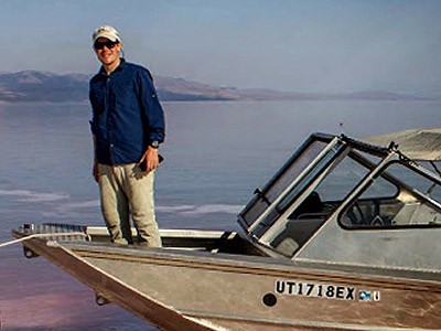
With her former graduate student, USU alum James White ‘15MS, now of the U.S. Geological Survey, and USU Ecology Center colleague David Tarboton, professor in the Department of Civil and Environmental Engineering, Null published findings in the Dec. 7, 2015, online issue of PLOS ONE.
The USU team’s research was funded by a research grant from the Utah Department of Natural Resources’ Great Salt Lake Technical Advisory Council and support from the Utah Division of Forestry, Fire and State Lands.
Seventy-five miles long and nearly 35 miles wide, the salt water remnant of ancient Lake Bonneville teems with aquatic life and serves as a critical flyway for millions of migratory birds. Yet the lake, ringed by an extensive network of wetlands and adjacent to Utah’s population and industrial center, is vulnerable to climate change and development pressures. The lake contributes an estimated $1.3 billion each year to Utah’s economy, including $1.1 million from mineral extraction, $136 million from creation and $57 million from a burgeoning brine shrimp industry that fuels, among other things, South Asian fish farms.
Until 2013, flow between the Great Salt Lake’s north and south arms was limited to two 4.6-meter-wide culverts, installed with the original causeway; an 88-meter breach added in 1984 and the semi-porous (though settling and becoming less porous) rock-filled causeway. That year, Union Pacific Railroad closed the causeway’s culverts due to safety concerns.
“Ecological and industry uses of the lake are dependent on long-term salinity remaining within physiological and economic thresholds,” Null says. “However, optimal salinity varies for the ecosystem and among the stakeholders.”
Upon removal of the culverts, Union Pacific Railroad proposed four different bridge designs, but the lake’s decision makers haven’t settled on the best solution.
“We investigated the effect each bridge design would have on lake elevation and salinity in both arms by updating and applying a model developed by the U.S. Geological Survey,” Null says.
Overall, she says, the USU researchers found the lake’s salinity is sensitive to bridge size and depth, with larger designs increasing salinity in the south arm and decreasing salinity in the north arm.
“Working with bridges, you’re constrained – you don’t have a lot of knobs to manage,” Null says.
She and her colleagues propose a fifth option: an adaptable bridge design with controllable gates or adjustable depths that would allow more flexibility for salinity control depending on conditions and needs.
“Managing terminal lake elevation and salinity are complex challenges,” Null says. “Our research illustrates that flow modifications can’t be separated from lake salinity, ecology, management and economic uses.”
Related Links
“Aggie Scientists Probe Vital Signs of Ailing Western River Basin,” Utah State Today
USU Department of Watershed Sciences
USU Ecology Center
USU Quinney College of Natural Resources
Contact: Sarah Null, 435-797-1338, sarah.null@usu.edu
Writer: Mary-Ann Muffoletto, 435-797-3517, maryann.muffoletto@usu.edu

Recent USU graduate James White '15MS, now an employee of the U.S. Geological Survey, is lead author on a paper with faculty mentors Sarah Null and David Tarboton that explores the effects of the Great Salt Lake's railroad causeway.
TOPICS
Research 878stories Community 445stories Utah 371stories Environment 263stories Water 258stories Alumni 181stories Ecology 173stories Geosciences 74storiesComments and questions regarding this article may be directed to the contact person listed on this page.


